Miami Beach Building Subsidence Varies, With Construction Linked to Continued Sinking
Satellite measurements found uneven sinking across 35 buildings, raising questions about construction’s role and potential exposure for property insurers.
Uneven settling across Miami Beach’s high-rise districts may be tied to continued building activity, a study of satellite measurements found. For insurers and property owners, the concern is not simply that some buildings have moved: it’s that neighboring structures have settled at different rates, and researchers say nearby work may accelerate the process.

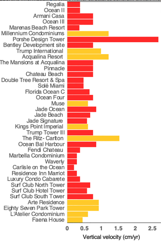
The study tracked 35 buildings in Miami Beach, Sunny Isles Beach and Surfside using satellite-based Interferometric Synthetic Aperture Radar, or InSAR. Measurements covered the past decade and showed that some buildings moved downward about 2 centimeters between 2016 and 2023. Others in Sunny Isles Beach and Surfside sank more than 8 centimeters over the periods measured, a distance the source describes as about three inches.
Published in Earth and Space Science in late 2024, the research was authored in part by University of Miami professors Farzaneh Aziz Zanjani and Falk Amelung, alongside researchers from universities in Florida and Germany. The paper has drawn renewed attention after coverage in the Miami Herald and other publications. Its findings offer a building-by-building view of movement that conventional observations may not capture as readily across a dense coastal skyline.

Construction and the ground beneath buildings
The researchers describe the mechanism as prolonged deformation in sandy layers within the limestone beneath the structures. In the study’s abstract, they write: “We attribute the observed subsidence to load-induced, prolonged creep deformation of the sandy layers within the limestone, which is accelerated, if not instigated, by construction activities.” In other words, the weight of buildings and nearby construction may contribute to gradual rearrangement in the underlying material.
Some settling is expected when a large structure is built, and it usually slows or stops soon after construction, as reports cited in coverage of the paper have described. The researchers’ concern is that some observed movement appears to continue, while measurements from more recent periods correlate with construction-related effects. That pattern complicates any simple assumption that a building’s initial settlement will fade with time.

The paper’s conclusion leaves open whether movement will eventually ease at particular buildings. “There are no indications that subsidence will come to a stop,” the authors write. They say buildings moving at a constant rate may continue to settle; movement that declines exponentially could eventually cease. But nearby construction vibrations, they add, may restart grain rearrangement and accelerate settling again.
That distinction matters because movement at one site may not predict movement at the next. Differences in building weight, ground conditions and construction activity could produce different outcomes across a compact area. The study does not establish that every building will continue sinking, nor does it quantify the future movement of individual structures. It does, however, identify a possible mechanism for renewed or prolonged settling that property owners and insurers may need to consider when assessing a specific location.

Why rates matter to property risk
The buildings identified include the 60-story Porsche Design Tower, where residents have reported cracking and leaks, and Trump Tower III, which the source describes as settling at almost a centimeter per year. The study also identifies movement at 87 Park, adjacent to the site of Champlain Towers South. The authors say subsidence affecting nearby low-rise buildings with relatively small structural loads is “almost certainly driven by construction activities.”
These observations should be kept in context. The paper noted that Champlain Towers South showed no signs of subsidence before its 2021 collapse. Engineering reports attributed that event mostly to deteriorated support columns in the 40-year-old condominium building. The study’s observations about other nearby structures do not establish a connection between their settling and that collapse.

For insurance underwriters and claims handlers, varying rates could make property-level information more useful than broad assumptions about a neighborhood. A measured change in ground elevation does not, by itself, show that a building has suffered damage or will produce an insurance claim. But where settling continues, differential movement may contribute to structural problems and could affect how insurers evaluate exposure, investigate reported damage and compare risks among nearby properties.
The Herald reported that managers of the buildings cited in the study declined to comment after being contacted. Sunny Isles Beach representatives said the previous year that they had received no reports of damage associated with settling. Those responses describe the information available to them at the time; they don’t resolve how movement may change as construction continues.
The key question is whether future measurements show settling slowing, holding steady or accelerating near active construction. InSAR provides a way to track surface movement across multiple buildings, while building-specific inspections and records can help determine whether that movement corresponds to physical damage. The study’s findings make continued monitoring relevant for owners and insurers in a low-lying area where construction and subsurface conditions may interact.