Bay of Bengal System Raises Prospect of Heavy Rain Across Southern India
A developing system could bring very heavy rain to Coastal Andhra Pradesh, alongside a broader spell of showers, thunderstorms and strong winds across the peninsula.
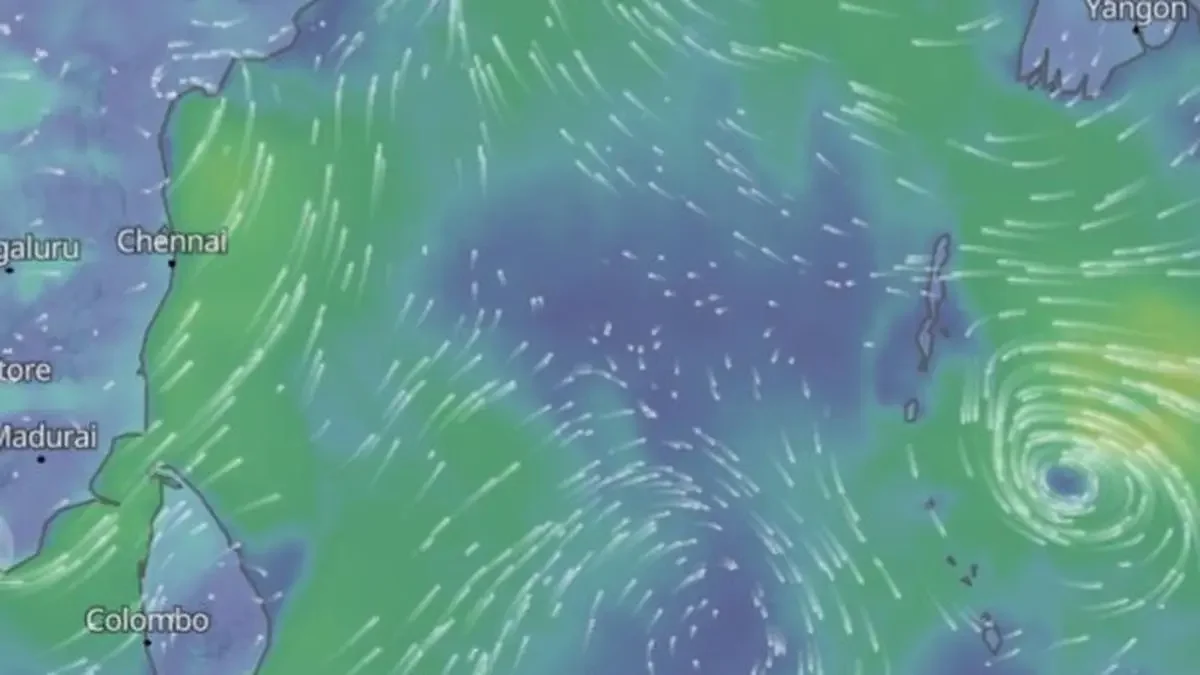
A developing system in the Bay of Bengal could bring another round of heavy rain to southern India within days of severe cyclone Arnab. The system was about 1,520 km south-east of Chennai on Friday morning. It may form into a depression on Saturday, with further strengthening possible as it moves towards the Andhra Pradesh coast.
The main rainfall concern is Coastal Andhra Pradesh and Yanam, where isolated very heavy rain of 11.5-20 cm is forecast on Tuesday and Wednesday. Tamil Nadu, Puducherry and Karaikal could receive isolated heavy rain on Tuesday and Wednesday. Coastal Andhra Pradesh and Yanam are also forecast to see heavy rain on Monday and Tuesday. Kerala and Mahe, coastal Karnataka, and South Interior Karnataka are among the other areas that could receive heavy showers.
The system’s possible intensification adds uncertainty to a forecast that already points to several days of unsettled weather. The India Meteorological Department has said the depression could strengthen at least into a deep depression, the second-highest category among low-pressure systems. Favourable conditions over the ocean and in the atmosphere appear to support that possibility, though the system’s eventual strength remains uncertain.
Rainfall could spread across the peninsula
Forecasts describe a changing pattern, with scattered showers in some areas giving way to broader rainfall in others. Rayalaseema, Tamil Nadu, Puducherry and Karaikal, and North Interior Karnataka are expected to have isolated to scattered rain for six days from Friday. Kerala and Mahe, South Interior Karnataka, Coastal Andhra Pradesh and Telangana could see similar conditions for three days, with rainfall returning on Tuesday and Wednesday.
Lakshadweep is forecast to receive isolated to scattered rain for three days from Monday. Coastal Karnataka is in the outlook for Saturday and Sunday. From Monday, the expected rain coverage broadens: coastal Karnataka, Kerala and Mahe, and South Interior Karnataka could have fairly widespread to widespread rainfall for three days. Coastal Andhra Pradesh and Yanam could see a similar pattern on Monday and Tuesday, with Telangana following on Tuesday.
These different forecast categories matter to people planning activity across the region. Scattered rain suggests showers may affect parts of an area, while widespread conditions point to a broader footprint. Neither description means rain will fall continuously or equally across every location. The timing and distribution may vary, particularly as the Bay system develops and interacts with other weather features.
Thunderstorms and strong winds add to the risk
Rain is only part of the outlook. Thunder squalls with winds of 50-60 km/hr, gusting to 70 km/hr, are expected over Telangana on Sunday and Tuesday. Strong surface winds are also forecast across North Interior Karnataka, South Interior Karnataka, Coastal Andhra Pradesh and Yanam, and Rayalaseema for four days from Friday.
Thunderstorms, lightning and gusty winds are forecast over Coastal Andhra Pradesh and Yanam on Tuesday. Kerala and Mahe, along with both North and South Interior Karnataka, could experience wind gusts on Sunday and Monday. Coastal Andhra Pradesh and Yanam are in the outlook for three days from Friday, while Rayalaseema could face a four-day spell. Tamil Nadu, Puducherry and Karaikal may see thunderstorms on Wednesday and Thursday; coastal Karnataka is also in the outlook for Sunday and Monday.
The timing varies across states and districts, so the forecast describes overlapping periods rather than one uniform event. For residents, transport operators and businesses with outdoor work, the combination of rain, lightning and gusts can disrupt plans even where the heaviest rainfall is not expected. The forecast gives specific wind speeds for Telangana, while the outlook for several other areas identifies strong winds or gusts without providing figures.
Why rain may continue after Arnab weakens
A separate weather feature linked to Arnab is also expected to contribute to unsettled conditions. Its remnants have weakened into a well-marked low over central Chhattisgarh, but the loss of strength in the original system does not by itself signal an immediate end to rain. The remaining circulation is expected to interact with an approaching western disturbance, associated circulations and a long trough. That combination could bring rain, thunderstorms, lightning and strong winds to parts of north-western, western, central and eastern India over the next few days, as well as affecting parts of the South Peninsula.
The trough connects several of these features. It stretches from the remnant circulation over central Chhattisgarh and adjoining Odisha, across Telangana and North Interior Karnataka, towards another cyclonic circulation over south Konkan. Along an elongated zone of low-level wind convergence, air rises and can support cloud formation and precipitation. In practical terms, the original low can weaken while the larger circulation and the trough continue to help produce showers.
The South Peninsula therefore faces two related sources of unsettled weather: a possible new Bay of Bengal depression and the lingering influence of Arnab’s remnants and associated features. The first could strengthen and move towards the Andhra Pradesh coast; the second may keep rain and storms active across a wider area. How those systems develop will shape the timing, coverage and intensity of rainfall over the coming days.
For now, the clearest signal is a period of changing conditions, with the heaviest forecast rain focused on Coastal Andhra Pradesh and Yanam, and showers and storms extending across several neighbouring states and territories. The system’s strength and its interaction with the trough remain the main factors to watch as the forecast period unfolds.